| |
|
 |
|
There's a
lot of nonsense talked about Dunwich. In
some books, it seems to have taken on the
proportions of some mythical lost city of
Atlantis. One imagines something like
Manhattan, slowly sinking beneath the
waves. One book I own suggests that
medieval Dunwich had 50 churches! It
wasn't that big, only the same
size as several other East Anglian towns
of the time. No, the real story of
Dunwich is much more exciting than the
fantasy. To start with, we need to
recognise how much the Suffolk coast has
changed in the last 2000 years. The
Dunwich area has changed no more than
anywhere else. Further south, a large
number of villages and their churches
have been lost to the sea, and to stand
in Aldeburgh is to see a town
cut in half. The Romans built Walton
Castle near Felixstowe; but today, its
ruins are more than a mile offshore,
beneath the waves. North of Dunwich, the
sea has carried off most of Pakefield in
the last century, but further north than
that, the old centre of Lowestoft is now further
away from the sea than it was 500 years
ago. Tides are funny things.
|
The
Romans knew Dunwich, and one theory suggests that
it might have been Dumnoc, the see of
the Bishop who would become St Felix. Miles Jebb,
in his book Suffolk, describes Dunwich
as the 'ignition point of English Catholicism'.
However, there seems to be very little evidence
for this, and more recent research seems to make
it increasingly unlikely. Dumnoc was
probably Walton Castle, now submerged beneath the
waves off the coast of Old Felixstowe. It was from here that the
missionaries set out across the land of the
Angles, working very much against the grain until
St Augustine arrived, and turned them into the
establishment.
Christianity
has undergone many changes in the 1300 years
since Felix and Augustine; but when the new
Anglican Diocese of St Edmundsbury and Ipswich
was created in 1913, the Church of England chose
'Bishop of Dunwich' as the official title of the
Diocesan Bishop's assistant. If they'd waited
eighty years, they would probably have made him
Bishop of Walton, but never mind. The real
Bishops of Walton didn't hang around for long.
They moved their see soon after its
establishment, and North Elmham in Norfolk became
its seat. The ruins of the cathedral still
survive there. The see later moved on to
Thetford, and then in the 11th century to Norwich
- but that's another story.
Within
20 years of the Norman conquest, Dunwich was a
town of 3,000 people. It had six parish churches,
with at least two other chapels of ease. The
parishes were All Saints, St Martin, St
Leonard, St Nicholas, St John the Baptist and
St Peter. Two known chapels of ease were
St Bartholomew and St
Michael. There was also a Knights
Templars church.
In
1199, Dunwich was granted a royal charter, and
become a Borough, electing a council, as well as
magistrates and officers, two bailiffs, a
recorder and a coroner. In 1279, we are told that
Dunwich possessed 80 large ships. It was, above
all else, a prosperous town, and this is what
marked it higher than Ipswich, which had fallen
on hard times. The sea was already making
incursions, but the people of Dunwich
strengthened the sea walls, because this was a
town worth defending. Throughout the 13th
century, we read of defences being erected, and
then moved as the forces of the sea changed their
point of attack. In 1295, Dunwich was
enfranchised to send two members to Parliament,
elected by the freemen of the Borough.
The
decline of Dunwich begins with a storm. The 14th
century was not kind to it, and on the 14th
January 1328 a wind of hurricane proportions
drove the sea against the spit of land called the
Kings Holme, shifting the shingle so that it
effectively blocked off Dunwich harbour. The
harbour mouth was more or less where the car park
is today. This was a disaster for Dunwich.
Instead, all ships, and thus all goods and
revenues, went into Walberswick instead. This was
the start of a violent disagreement between the
people of the two towns, which went on for nearly
a century, and resulted in several deaths.
But
without any revenue, the town was not worth
defending. The sea continued to make incursions,
and during the fourteenth century Thomas Gardner
reports 400 houses, 2 churches, as well as shops
and windmills, succumbing to the tempest. These
were St Martin, on the east side
of town, which last instituted a Rector in 1335,
and St Leonard.
St
Nicholas, the main church of the town,
was cruciform with a central tower. It was last
used in 1352. It was abandoned, because of its
proximity to the waves, but actually survived,
and became derelict, finally going over in the
late 14th century.
The
story of destruction rapidly accelerates. As the
sea approached the market place in the 1540s, the
cruciform St John the Baptist
was threatened. Miserably, the churchwardens sold
off all the plate to raise money to build a pier
to deflect the waves from their church. But it
didn't work, and the church was dismantled to
recover materials.
St
Peter stood until the 1650s, a few
lonely houses huddling around it. It seems to
have been broadly similar to Blythburgh in proportion and size. William
Dowsing
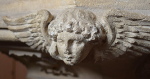
visited in 1644, and, without an inkling of the
absurdity of it, ordered the destruction of sixty
three cherubims (in the roof), sixty at
least of Jesus written in captial letters on the
roof, and forty superstitious pictures (in
glass), and a cross on the top of the steeple.
Before the church finally fell, the bells were
removed to All Saints, and the
lead and timber taken in to store for future use.
The east end of the chancel went over the cliff in
December 1688, the tower following ten years
later. The remaining Dunwich houses were redrawn
into the parish of All Saints, now the sole
survivor.
All
Saints, we know, was Norman at its heart, with
Perpendicular work from a makeover of the 1530s.
This included the construction of a north aisle. Dowsing visited here as
well, ordering the destruction of thirty
superstitious pictures, twenty eight cherubims
and a cross on the chancel. But no one
wanted to live in Dunwich anymore - what was the
point? The land was worthless, there was no
fishing fleet, no work at all. By the middle of
the 18th centry, the town had been all but
abandoned. The last Rector left All Saints in
1755. The church was still used for baptisms and
burials until the new church of St James was built in the village.
Then, it was abandoned, and it fell into
dereliction, like many Suffolk churches of the
time.
And
yet, the town continued to elect its two members
of parliament! The freemen of Dunwich had passed
on their honour to their ancestors, who now lived
all over England. At the end of the 18th century,
or so the story goes, people would travel to
Dunwich for elections, going out in a boat to the
point where the town hall used to be to cast
their vote. The freemen also continued to elect
magistrates, bailiffs, and so on, and went about
their business in a similar manner. By the time
of the 1832 Reform Act, which abolished Rotten
Boroughs like Dunwich, there were just 8
residents left in the constituency, which still
returned two MPs. Today, you can still see the
official seal and instruments of power of Dunwich
Corporation in an excellent museum in the
village.
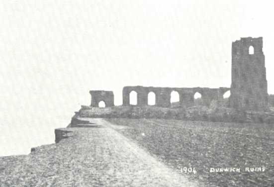
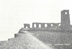
All
Saints stood surprisingly well, and when I was
younger I met an old Suffolker who remembered
climbing its tower. But during the early years of
the twentieth century, after the new pier was
built north of here at Lowestoft, the pattern of
the tides underwent an alarming change, and in
February 1904 the sea began to take the ruin of
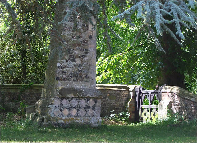
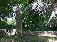
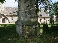
All Saints off to its destiny. The tower went on
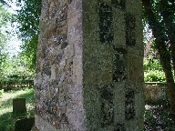
the 12th November 1919, leaving just a single
buttress, which was rescued and reset in the
graveyard of the new church of St James. Hauntingly, it carries
graffiti from sightseers who visited it during
its lonely sojourn on the clifftop. Also in the
graveyard is part of a pillar from the former
acade, recovered from the beach.
All
Saints was one of Suffolk's biggest churches; at
149 feet long, it was of a scale with Southwold. This gives us some idea
of the speed with which the cliff eroded away.
Throughout the twentieth century, people have
come to Dunwich to see the last relics of All
Saints. Until the 1950s, it was still easy to
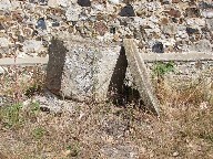
find identifiable lumps of masonry on the beach.
When I first came here in 1985, the bones of
those buried in All Saints' graveyard protruded
gruesomely from the cliff, and a single
gravestone, to John Brinkley Easey, stood in an
inconceivably bleak loneliness at the cliff top.
But this has now gone,
removed to the safety of the churchyard
of St James, and one would not think that
there was ever anything like a town here
now. The last remains of the Greyfriars
monastery, westwards of All Saints,
should be good for another fifty years or
so. The local planning authorities have a
policy of managed retreat - sea defences
will not be built again in Dunwich. But
it is still possible to walk through the
ruins of the Greyfriars monastery, used
for grazing sheep now, and through a gate
near the cliff top. The footpath here
passes through the edge of the former
graveyard of All Saints. And that is all
that is left.
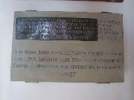
Well, not quite. For a brass
rescued from the church in the
mid-eighteenth century turned up in the
hands of the Norwich corporation. It was
given to St James in 1927, and is
now proudly on display inside.
|
|
 |
|
|
|